A conceptual model designed to assess the suitability of spatial databaise for specific rural mapping tasks
Из материалов международной конференции " Интеркарто - 6 " ( г. Апатиты, 22-24 августа 2000 г.).
David Fraser
Department of Land Information RMIT University
e-mail: david.fraser@rmit.edu.au
Abstract. One of the difficulties associated with the use of digital spatial databases in a GIS is the lack of information relating to the nature of the data and its quality. In the rural environment, digital spatial databases are being used more and more to provide information to assist with specific land management issues. Often the user of the data may have limited knowledge relating to the appropriateness of the data for the task.
This paper outlines a conceptual model that places the database being investigated into a capability class according to the existence of required data layers and the quality of the data on the layers. This approach provides the user with an assessment of the databases suitability for a specific rural mapping task.
Introduction
Often overlooked when dealing with digital spatial data uncertainty is the need to consider the external factors that introduce uncertainty into the modeling. For instance, the knowledge the user has of the database may be such that they are uncertain as to the suitability of a database for a specific application. With this in mind it is worth considering a model which assesses the suitability of a database for a specific land management application. Consideration of the availability of required data layers and the quality of the database layers can provide the means of assessing the database suitability.
The model proposed in this paper considers the user of the cartographic products, created from the digital spatial databases, as being the primary focus.
Users of cartographic products generated from digital spatial information systems fall into three broad categories:
Those who have little knowledge regarding how the product was created.
Those who have an intimate knowledge regarding specific stages of the process used to create the product.
Those who have an intimate knowledge regarding all the stages associated with the creation of a map from digital data.
Some professionals who have little education in the mapping sciences are attempting to produce their own digital databases and associated cartographic products. This lack of education means that key requirements, at each stage in the production of the final cartographic visualisations, may not be attended to.
Digital spatial databases store aspects of the best established knowledge relating to phenomena. This is the case whether the data has been captured by ground survey or from existing geometric representations (eg. paper maps). Nevertheless, according to Jones (et al, 1996, p. 904) «We store approximate, error prone characterisation of aspects of the real world.»
One of the key components of a digital spatial database that may remain hidden to the average user is the data quality indicators. Data quality has to do with errors, uncertainty, accuracy and precision. Errors and uncertainties can occur at all stages in data processing and are often overlooked in the creation of map products. The determination of errors and uncertainties often falls into the «too hard» category.
The discussion relating to issues of database quality have been going on for some time now. It is a predominant concern of those involved in spatial database creation. The need for quality data and data quality indicators is now accepted as the norm. The approach taken to attain a particular level of data quality and the approach to documenting the data quality have been given specific attention over recent years.
Data Quality Documentation
Prior to digital databases, analogue mapsheets provided information in the margin that allowed the map-reader to determine the suitability of the map for a particular purpose. Most map-readers, through familiarity with such products, were able to make allowances for the feature generalisation inherent in any map.
Spatial data, in the modern context, began as the product of the line digitising of the existing analogue maps. Coordinates provided the means of reproducing the graphic image, found on the original map, in new forms and at a variety of map scales. What was lost in this process was the link to the original information about the map.
Initially most of the effort relating to digital mapping was concerned with overcoming the limitations of the hardware and software. Over time both the producers and users of the digital spatial databases required more and more sophistication from the digital data. The technology evolved to the point where it no longer limited the activities of those involved in mapping. It was recognised that mimicking the original paper product was limiting the use of the data. Algorithms were developed which provided the ability to undertake sophisticated spatial analysis on the data. Attention began to focus on improving the quality of the data.
The use of the higher quality data sets quickly showed up the limitations in other digital data and the need for data standards became evident.
Spatial data quality documentation has improved over recent years partly in response to the needs of the users. Quality digital spatial data has the potential to be used for sophisticated data analysis where the quality of the results relies heavily on the quality of the data used to obtain the outcomes. The quality of the digital data is determined primarily through viewing the data documentation.
Often spatial data comes from a number of different sources and there is a need to integrate the data. In September of 1997 the Industry Commission in Australia, released a statement which said in part, that « much of the data collected in Australia relating to the physical condition of natural resources lacks comparability and uniformity. Lack of comparability means no meaningful comparison is possible between different land management practices and significantly reduced the usefulness of the information collected.» (Hazel Baker, 1998, GIS User Number 27, April-May 1998, p. 42).
The model presented in this paper attempts to incorporate the structure provided in various standards and to address, in part, the reluctance of the data providers to adopt a uniform standard for their datasets. From the users point of view it is difficult to obtain information about the data quality and often the metadata documentation is quite technical and difficult to comprehend.
Acknowledging that true conformity and standardisation of spatial datasets is still many years away, the author of this paper has developed a conceptual model which places each dataset into a particular capability class based on the completeness of the data and the type of metadata available. First comes the determination of the availability of required data layers along with the features on each layer, this is called the database suitability assessment. Second, the metadata is interrogated and a determination of the capability of the database to provide information for a particular user defined rural land management task is made. Each data layer required for a mapping task is placed into a capability class, which allows the database suitability for a specific mapping task to be determined.
Capability Assessment
The proposed model presented in this paper treats the data quality issues both from the data producer s point of view and also from the user s point of view. The onus is on the data producer to provide, at the very least, an indication of the quality of the data and hopefully a full metadata outline of the data quality.
Consideration is given to the users of mapping databases, who vary in relation to their understanding of the limitations of such databases. There are many instances where a database has been used to produce output that is inappropriate for the task at hand. This may occur if the user accepts the digital data as being suitable for plotting at any scale or for any purpose.
The information relating to each land management issue states what the clearly defined database requirements are. A link between the established requirements of any spatial database when applied to a specific land management issue and the database under investigation is also established and an investigation of the database begins.
A «rural land management issues» listing is a central part of the system. The user defines the general mapping task by identifying the land management issue under investigation. The system then seeks out the desirable layers and features stored against this issue. This then forms the standard against which the database under investigation is tested. In other words, an expert group has determined what layers and features are required, at a specified general mapping scale, if a rural mapping task is to provide worthwhile outcomes. A database is tested against this standard set of requirements. The system then reports on the mismatch between that which is required and what is available.
The model presented below not only provides the user with information relating to the data requirements for the mapping task but also determines the capability of the database under investigation for the mapping task, based on the data quality.
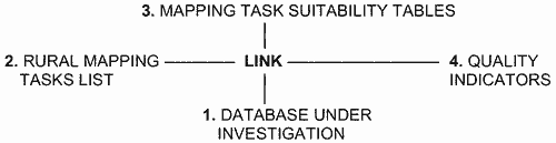
The model has a number of components that are linked together and provide the means of determining the capability, or suitability, of a database for a specific mapping task. The figure below presents a schematic representation of the system:
In general the system is designed to analyse an existing database (1) which a member of the rural community intends using for a designated rural mapping task (2). The layers and features on each layer, of the database under investigation, are compared with a list of the required layers and features (3), for a specific rural mapping task, to determine any mismatch. The database is given one of five suitability grades from highly suitable to most unsuitable (3). Once the initial grading is established further interrogation of the database is undertaken to determine the quality of the data by analysing any metadata associated with the database (4). A final assessment of the database capability is then provided as a report to the user.
Concluding Comments
The capability model proposed in this paper is task specific. The database may prove unsuitable for use in one land management situation but this does not mean that it is unsuitable for all land management applications. A capability assessment must be undertaken for all land management issues identified and a new comparison made for any new land management issue.
The database capability assessment has associated with it a link to a database containing cartographic theory which should be considered when using a digital spatial database. The theory can be accessed by the user and aspects of the theory are contained in the final database capability report.
Planned development of the model will see the introduction of data error propagation modeling and the creation of graphical indicators of the information content of the visualizations created by the modeling.
References
Baker H. GIS User, Number 27, April-May 1998, P. 42
Jones C.B., Kidner D.B., Luo L.Q., Bundy G. Ll and Ware J.M., 1996, Database Design for a Mutli-scale Spatial Information System, International Journal of Geographical Information Systems, Vol. 10, N. 8, P. 901-920 (research article), Taylor & Francis Ltd.