GIS-based infomational-modeling computer system for estmation and analysis of radioactive contamination of surface water.
Из материалов международной конференции " Интеркарто - 6 " ( г. Апатиты, 22-24 августа 2000 г.).
Vorobiev V., Kiselev V., Korzhov M., Krylov A., Zhilina N.
Ecological Modeling Dep., Nuclear Safety Institute (IBRAE), Russian Academy of Science
e-mail: kis@ibrae.ac.ru
Abstract. The given work presents description and practical representation of the specialized system of computer models for estimation of consequences of radioactive accidents and other releases of radioactive substances to an environment (water systems). A number of models are integrated in specialized GIS (geographical informational system). The variety of models (model for river, for small simple lake, for complicated basins, etc.) on prediction of concentration in various types of water objects is stipulated by large zones of influence of nuclear reactors. The models are integrated in the number of confined chains that enable full calculation from an accident parameters to resulting pollution and health harm. On the base of calculated results appropriate actions are recommended. System is «open» so it can be expanded and improved by other models. A prototype of decision support system for emergency radioactive pollution based on the computer models complemented with regulative documents database is also presented. The system will support decision making on population protection in an emergency situation and «what if» process through radioactively dangerous object projecting. For creation of the computer bank of models and decision support system modern information technologies are used. Validation and verification of computer models are carried out now. Some of models were verificated on the Chernobyl accident contamination data.
Introduction
There are plenty of methods and models for evaluation of radioactive contamination of water objects, for prediction of behavior of radionuclides in basins, for estimation of population exposure, for analysis of possible health harm, for development of appropriate recommendations. The aim (and the result) of given work is an integration of several ecological and mathematical models into confined chain.
Radionuclides emission - Surface contamination - Basin contamination - Radionuclides behavior prediction - Estimation of internal and external exposure - Development of appropriate recommendations.
Such integration (on the base of specialized geographical informational system) makes this system convenient for evaluation of radioactive accident consequences, for calculation of limits of radioactive emission into basins, for estimation of possible harm from various radioactively dangerous actions. This system should be convenient tool for decision support for radioactive safety professionals responsible for environment and population protection.
For this purpose we have developed the system, which has following main advantages:
1. The models are integrated into the confined chain. No data other than hydrology data and appropriate information about an accident (atmospheric discharge, wastewater discharge etc) is necessary for radioactive doses and radioactive risk prediction and for developing of recommendations.
2. The system enables a customer to use experimental data for further calculations instead of intermediate calculation results, which permits to increase accuracy of final results (if experimental data are available).
3. All subsystems are open. It is possible to use them jointly with other models. It enables a customer to use most appropriate and convenient (from customers point of view) models in each particular case.
4. Quick «from start to end» prediction is possible.
5. Computer models included in the system are easy to use and have user-friendly interface.
6. GIS tools provide one with access to electronically stored geographical data, enables prompt, easy and convenient analysis of situation.
7. The system is flexible. It supports decision-making and enables «what if» process. It also gives you opportunity to evaluate sensitivity of results to input data.
8. It is possible to get final and intermediate results (at any stage) for any of external processing.
9. Models included in the system are generic and correctly describe radionuclides behavior in basins of some type in general. And they do not use specific characteristics of a particular object.
10. Coefficients, parameters, etc, that are necessary for confined work of the system, are available as an appropriate databases.
11. Each model operates in wide range of input data.
Description of the system
The system consists of the following elements:
1. Specialized geographical informational system Komponovka (based on GIS Mapinfo).
2. The model for prediction of radionuclides behavior in simple low-flow basins (Basin).
3. The model for estimation of internal and external exposure for various groups of population (water ways of exposure). This model evaluates radioactive risks and develops appropriate recommendations (Inter).
4. Model for a river (under development).
5. Model for complicated basins (based on the Princeton Ocean Model improved by PNNL). Linking of this model to our system is carried out now.
Fig. 1. System structure
Full description of the models you can find in [1] and [2].
For system to operate hydrological data is necessary. GIS-based computer hydrological maps do exist nowadays. More precise information concerning basins (type of sediments, water humidity etc) could be found in special hydrological reference-books (see [3] for example). On the preparatory stage this information is transferred to GIS databases. Also information about different population groups rations and types of external activities is collected and stored.
If necessary models parameters, doses limits etc could be corrected also. All these actions are carried out on the preparatory stage (before an accident). After that the scheme of operation of the system varies from different circumstances. It depends on accident parameters, information available, type of water object, customer s requirement. In fact:
1. Radionuclides can get into hydrological network as a result of an accident or as a result of regular discharges.
2. Radionuclides can get into hydrological network by different ways: atmospheric discharge, wastewater discharge etc.
3. The contamination data can originate from two sources experimentally measured or predicted by a model. For example a model of atmospheric advection can calculate atmospheric discharge.
4. Characteristics of water objects vary substantially. We subdivide them onto three types: complicated water object, simple basin, river.
On the next stage parameters of an accident or a discharge are already known. Format of input data and the list of water objects that should be the subject of prediction is also known at this stage. First of all, if data (experimental or calculated) concerning contamination presented spatially (with no link to water objects), then Komponovka determines intersection of contaminated area with local hydrology and prepares information about contamination of each specific water object. After that depending on type of a water object model for radionuclides behavior prediction is chosen. For simple water objects the Basin model is used, for large complicated water objects POM model should be used, for rivers a river model. Calculated by Komponovka integral data concerning contamination of a specific water object and collected previously general information about the water object are transferred to chosen model for contamination prediction. On this stage other ways of contamination (wastewater discharge, washing out of contaminated riverbeds and water collection area, secondary contamination of water from sediments) could be taken into account. Then contamination of the water object is predicted for some period of time. Resulting contamination of water and sediments is transferred to the model «Internal and external exposure» Inter. After that according to collected previously data on population groups rations etc doses are estimated. The estimation results are compared to appropriate limits. On the base of that data «module of warnings and recommendations» analyzes critical (contributing most) ways of exposure and issues appropriate warnings and recommendations if necessary.
Fig. 2. Water objects colored depending on their contamination
The results (finite and intermediate) can be presented as graphs or maps. They also can be printed or reviewed interactively.
The system can operate without any of its parts or with another external model attached. For example the operation without Komponovka module is convenient in case when a source of contamination data are experimental measurements of water and sediments contamination instead of a model of atmospheric propagation.
The system is designed for MS-WINDOWS 95/98. It is developed with the Mapbasic 4.0 (geographical part) and VISUAL BASIC 5.0. The system has bilingual (russian and english) interface. The prototype of the system was used in realization on Command and Headquarters Training «Polyarnye Zori - 95». This Practical Game was held by EMERCOM and UN Department of Humanitarian Affairs and took place in Apatity, Murmansk region, May 29 - June 2, 1995. In future supposed in future to give attention to more complex models, additional processes, updating and development of the databases. It was a foundation laid for development of similar systems for other types of contamination (chemical for example).
Models description
Computer base model for radionuclides behavior prediction for simple basins contaminated due to accident or regular discharge (BASIN).
Fig. 3. Example of comparison of calculation results to experimental data
From the large spectrum of models we have chosen the model described in [1]. The reasons are following:
1. This model was developed for basin s type that is prevailing in Russia.
2. Chernobyl accident experience was taken into account while building of the model.
3. This model is supplied with real coefficients and parameters necessary. So it can operate with minimal input information.
4. The model allows to predict basins contamination in cases of nonrecurrent discharge, chronic discharges, combination of nonrecurrent and chronic discharges. It is supposed that nonrecurrent contamination is connected with an accidental atmospheric discharge or wastewater discharge. Chronic contamination may be connected with contaminated river waters inflow, with washing out of contaminated riverbeds and water collection area, with recurrent regular discharges.
The method of calculation of radionuclide concentration in water and sediments is based on the well practically worked out two-chamber model of ideal mixing radioactive impurity. The model reflects exchange processes between radionuclides dissolved in water, sorbed on suspended particles and sited on sediments. Main processes of transfer of radionuclides: running water outflow out of the basin bounds; sedimentation of suspended particles; stirring up of contaminated sediments; diffusive exchange of radionuclides between water and sediments, sludge etc.
The model was verified on the experimental data on contamination (resulting from Chernobyl accident) of water and sediments of four lakes: Svyatoe Lake (Belorussia) [4], Bracciano Lake [5], Esthwaite Lake and Windermere Lake [6]. Comparison shows that the model correctly reflects the results in general. But in some experimental points one can see deviations. Such deviation could be explained by some inadequacy of experimental data concerning hydrological surrounding, errors in measurements, and some disadvantages of the model. Nevertheless comparison results shows that the model is applicable even to stratified basins for average and long time predictions.
Model for complicated basins
We are going to use for this purposes well-known three-dimensional numerical ocean model (Princeton Ocean Model) improved by Pacific Northwest National Laboratories (PNNL) [2]. Verification of this model based on the data on the contamination resulting from submarine accident in the Chazhgma Bay [7] is carried out currently. Linking of this model to our system is also in process now.
Computer model «Internal and external exposure (water ways)» / INTER
For decision making on radioactive protection along with radioactive contamination prediction, estimation of possible health harm for different population groups is required. For that purpose prediction of doses and radioactive risks is necessary. To find easiest way of reducing negative effects, one should find out what contributes most to final doses. These problems are solved by the model «Internal and external exposure». This computer model was developed according to Nuclear Safety Regulations (NSR-96) [8]. Similar models are recommended by U.S. Nuclear Regulatory Commission [9], Bundesministren Des Innern (Germany) [10].
This model is designed for prediction of doses of internal and external exposure (related to water objects), for estimation of risk from stochastic effects, for developing of appropriate recommendations. The model estimates effective dose (dose on an entire body) and equivalent doses for different organs of human organism. It compares results to norms established by Nuclear Safety Regulations (NSR-96) [8]. This model takes into account the following ways of exposure related to water objects: exposure from consumption of contaminated food and drinking water (internal exposure); exposure from swimming, boating, staying at the beach, etc (external exposure). The model requires no information concerning contamination which cannot be calculated by models for prediction of radionuclides behavior in water objects (in our case this is radionuclides concentration in water and sediments). This computer model is «quick». So it can be used in extreme situations. One of the advantages of the model is its ability to estimate contribution to resulting dose of every radionuclide, every type of food and every type of external activity. So one can determine critical (contributing to resulting doses more than others) ways of exposure. It enables reducing of doses with minimal side effects. For example, to avoid consumption of type of food responsible for the largest part of resulting doses may be the easiest and the cheapest way of population protection. Model is easy to use, supports decision making and enables and «what if» process.
Fig. 4. Internal exposure screen (model Inter)
Fig. 5. Screen of input data (model Basin)
Fig. 6. Contamination of water and sediments
Warnings and recommendations development
Warnings and recommendations are developed according to Nuclear Safety Rules (NSR-96):
There is a collection of controlled parameters and limit values for them, established by [8]. If one of the parameters exceeds its limit a warning is issued. A collection of radiation protection measures is also recommended by [8]. There also established limits for doses prevented by every measure. There are two levels of measures and doses prevented by them respectively «Level A» and «Level B». If doses prevented do not exceed «Level A» it means that there is no reason to take an action if this action is associated with local disruption of regular business and social activity. If doses prevented exceeds «Level A», but do not exceeds «Level B» decision should be made taking into account particular conditions and local circumstances. If doses prevented do exceed «Level B» appropriated protection measures must be carried out even if they disrupt regular business and social activity.
References
1. Vorobiev V.A., Kiselev V.P., Korgov M.Y., Krylov A.L. Computer system of models for prediction radionuclides behavior in surface water. Russian Academy of Science, Nuclear Safety Institute, Moscow, 1997.
2. Mellor G.L. Users Guide for a three-dimensional, primitive equation, numerical ocean model, Princeton University, Princeton, 1996
3. Elshin Y.A. Surface water resources of USSR. Basic hydrological characteristics. Kolsky peninsula, Hydrometereological publishing house, Leningrad, 1965.
4. Vorobiev V., Gorbachev A., Kanevsky M., Nosov A., Panchenko S., Evstratov E.,Medved J., Hitrikov V. Computer base model for radionuclides behavior prediction for simple basins contaminated due to accident or regular discharge, Nuclear Safety Institute RAS, Moscow, 1994.
5. Monte Fratarcangeli S., Pompei F., Quaggia S., Andrasi G., Modeling the behavior of 137Cs, 134Cs and 90Sr in lake systems, (results of research carried out using radioactivity measurement data collected following the Chernobyl accident), ENEA, ISSN/0393-6309, RT/PAS/89/31.
6. McDougall S., Hilton J., Jenkins A. A dynamic model of cesium transport in lakes and their catchments // Wat. Res., Vol. 25, N 4, 1991. - Р. 437-445.
7. Arutyunyan R.V., Danilyan V.A., Vysotsky V.V. et al. Analisys and estimation of radiological consequences of nuclear accident in chazhma bay. Russian Academy of Science, Nuclear Safety Institute (IBRAE), Moscow, Preprint IBRAE-98-09, 1998.
8. Nuclear Safety Regulations (NSR - 96). Moscow, Goskomsanepidnadzor of Russia, 1996.
9. Nuclear Regulatory Commission - 93, Response Technical Manual - 93, NUREG/BR-0150, Vol. 1, Rev. 93, November 1993.
10. GEMEINSAMES MINISTERIALBLATT, Bonn, den 15, August 1979 Nr 21 RdSchr v.16. 8. 79 Aligemeeine b-einehnuligsgrundlage fur die Strahlenexposition bei radioaktiven Ableitungen mit der Ablaft oder in Oberflachengewasser.
11. Vorobiev V., Nosov A., Kiselev V., Hitrikov V. Computer model for radioactive accidental contamination of water objects. Isvestia RAS, N4. Moscow, 1995. - P. 59-67


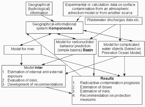 Fig. 1. System structure
 Fig. 2. Water objects colored depending on their contamination
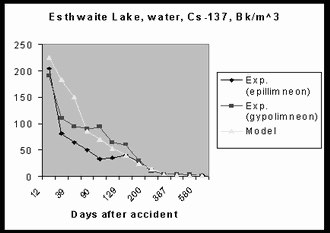 Fig. 3. Example of comparison of calculation results to experimental data
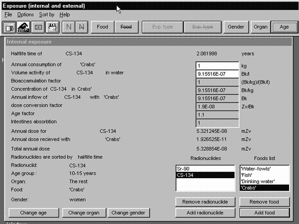 Fig. 4. Internal exposure screen (model Inter)
 Fig. 5. Screen of input data (model Basin)
 Fig. 6. Contamination of water and sediments


