Из материалов международной конференции " Интеркарто - 6 " ( г. Апатиты, 22-24 августа 2000 г.).
Laszlo Zentai
Department of Cartography, Etvosh University, Budapest, Hungary
e-mail: laszlo.zentai@elte.hu
Abstract. The term geographic information system (GIS) was nearly unknown twenty-thirty years ago. Likewise the terms of digital map, digital cartography were known in practice only by the lucky experts of the richest countries at that time.
Nowadays the GIS has became so important and wide spread that we may say a bit maliciously: it is in fashion. In the information technology there has always been fashionable sections, some of them were really important, useful, but the remaining part was only a short-lived fashion. In my opinion GIS is still looking for its real place, in some cases it is considered a wonder, a cure-all, which can solve every problem in a certain area. I don t really want to underestimate or overestimate the role of GIS, but as a cartographer, who basically deals with map producing, map publishing (previously with traditional methods, nowadays only by computer) I follow its spreading with critical attention.
Fig. 1. Corel QuattroPro data map sample
Unambiguosly shows the importance of GIS that some of their functions are already integrated into Office-like software packages to make their products more complete and more competitive, especially in the market of spreadsheet software (Microsoft Excel, Corel Quattro Pro). The GIS programmes are too complicated for the users (who only use word processing and spreadsheet software), so it is understandable and acceptable that these integrated functions of spreadsheet programmes are very limited and the further are only for experts. However, using these (relatively hidden) features of spreadsheets programs, thousands of users can create digital thematic maps without any practice and cartographic knowledge.
Of course looking at these maps as an output-oriented cartographer, I may call them only sketch. These maps are not intended to be published by offset printing.
According to my Hungarian and international experiences the output-oriented digital cartography uses the following types of software:
Ї Special cartographic software (e.g. Ocad, Ace). Because of the various cartographic demands, these programmes can be very complicated, they are very difficult to learn or they can satisfy only special fields of mapmaking.
Ї CAD (computer aided design): mostly it is a Hungarian speciality, but the basic software of the largest map publishing firms is AutoCAD (or partly Microstation). The main advantage of this type of software is the precise accuracy and the ability of handling large cartographic files (the data amount of a large city s map including street names can be very large). The disadvantages are higher price, relatively complicated usage, not WYSIWIG (what you see, is what you get). Nobody can say that the traditional map producing process was WYSIWYG, so the lack of this function is not a problem for professional mapmakers.
Ї General graphic software: fully WYSIWYG, their price is mostly lower then the other categories (CorelDraw, Freehand, Illustrator). One of the disadvantages is the lack of any cartographic relation, therefore it is not easy for beginners to choose the necessary functions among the whole palette offered by the software. Typical error of mapmakers using this kind of programmes is to apply as many special features as possible, and making the map too colourful. The ratio of Apple-MacIntosh computers is higher in computer graphics and desktop publishing than in other areas of information technology. In the other software categories the Apple-MacIntosh computers and programmes are nearly unknown.
Ї GIS software (Mapinfo, ArcView, Intergraph). For map making, map publishing only vector based software is taken into account. The very important advantage is the database connection, the intelligence of geographical objects. The main disadvantage from the output-oriented cartographic view that the objects are built from polygons if we want beautiful curves (like rivers, roads) we have to add a large number of additional nodes. Only the most complicated and complex versions or special modules (ArcInfo workstation version, Map Finisher, Map Publisher) can offer such special functions, which are essential for professional map publishing (colour separation, Bйzier-curves).
The GIS is not a universal cure-all, it has a suitable place and role in the information technology. The end of eighties, the beginning of nineties witnessed some changes in systems in Central and Eastern-Europe:
Ї the secrecy of topographic maps has come to end,
Ї the state monopoly of map publishing has come to end, new private enterprises were formed,
Ї the local self-governments, municipalities got larger independence instead of the former centralised state power.
However the self-governments used computers to be able to complete their tasks from the middle of eighties, but the first (not too complex) geographical information system has been developed in 1988 at the Budapest self-government. After the political and economical changes the GIS has became a very good business for the newly formed enterprises. They sold such products, which the customers had no doubt about their essence. This process still exists, the self-governments spend lot of money from applications and from other sources, what the small GIS firms kindly deliver for them. They don t always inform customer that the use of such requires well-trained experts. Nowadays the users of the most complicated GIS environments have already learnt the lesson and they know it from experience that the hardware and software together represent only a small ratio of the whole cost of a system. At the beginning the lack of digital maps was also the hindrance of the development.
The knowledge of experts increased, GIS systems are becoming more user friendly, and by clearing the market environment the GIS has became a fair business the competition situation has solved the problems of the initial stage.
The spreading of the web in the middle of nineties effects all the areas of information technology. With the help of the web such applications has became well-known, which previously were used only by experts. The GIS belongs to the winner area, but to preserve this stage it needs some development. It was necessary to solve the immediate response to the requests coming from the webserver, meanwhile the webserver must protect the valuable database. By default the webbrowsers support only raster images (GIF, JPG), where the data protections is not relevant. So in the first time the main problem of representation was the speed of webserver response to create the raster image answer.
The relatively easy realisation of raster based representation can express only a small part of GIS representation features. The vector based representation requires a special kind of software, a so called plugin. The plugin built in the browser enable us to view certain file formats inside the browser. According to the characteristics of the file format some new functions, menus may appear, like magnify, reduce, pan, database connection, etc. So the browsers can use the same representation and analysing functions like the simple GIS applications (of course the web environment lets the use of basic features only). Based on the characteristics of the relationship the browser can reach only limited kind of data, but the reason of this is not simply technical, but rather the data protection.
The GIS is a relatively narrow area compared to other parts of information technology, so it is not expeced that webbrowers will support this special claim. Nowadays the users are familiar with the web browser interface, so to download and install a plugin is not a hard challenge for them, it is rather an everyday custom, however large number is users are afraid of this incomprehensible and mystic operation.
The further disadvantage of web environment is the lack of common standardised GIS file formats supported by all major applications. So the main GIS software producers had to develop their own plugin for their application and the users had to install several plugins.
From the output-oriented cartographic point of view the web is a very amazing opportunity. It is a known task for cartographers to take into account the characteristics of the limited representation possibilities, like the optimising process of map in the web browsers window according to its limited size and resolution. It is nearly impossible to harmonise the requirements of display representation and printing, but their physical background is different (additive and substractive colour models).
Neither the vector based, nor the raster based solution can give suitable result for every user, so sometimes a so called hybrid format is used. Some file formats (mostly metafiles) can contain both raster and vector data. The most common web environment is the Adobe Acrobat PDF (portable document format). The PDF is compressed enough to be transferred via Internet and nowadays it is the most important document (including maps) exchange format. Using for example a citymap (starting from a vector based digital map) the PDF gives the possibility of searching text, so text objects, like street names are possible to find with the find function of Acrobat plugin.
Fig. 2. Database driven raster based web map of Budapest (11th district)
If the map comes from the desktop mapping direction, then PDF makes the very high level representation of the map possible both on the screen and printer. It is also possible to save the work (map) in PDF format in GIS environment. Of course we have to take into account, that we will loose the main advantage, the database connection.


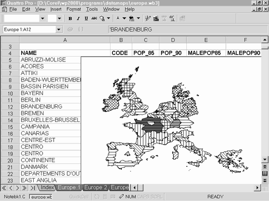 Fig. 1. Corel QuattroPro data map sample
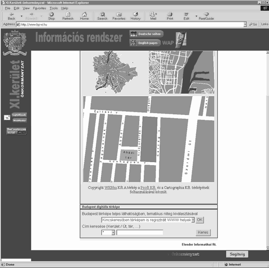 Fig. 2. Database driven raster based web map of Budapest (11th district)


