Scientific-methodical aspects of the regional expert system on environment prtection management
Из материалов международной конференции " Интеркарто - 6 " ( г. Апатиты, 22-24 августа 2000 г.).
Makarova T.D.. Makarova Z.V., Kalabin G.V.
Institute of the North Industrial Ecology Problems Kola Science Centre of RAS
e-mail: makarova@kolasc.inep.net.ru
Conservation of man s environment and natural-resources potential is the current task which solution is connected with the fundamental opportunity of long-term sustainable development.
Priorities of the main tasks may be changed at some stages of transition towards sustainable development, but the impact of environmental factor on making of decisions directed to reaching any of them is the same (fig. 1).
Fig. 1. Nature-protective orientation of the Sustainable Development aims
Necessity of the balanced solution of tasks on social-economic development and provision of favourable environmental state provides the control of triad society - economy - nature on the basis of system approach. At present conception of ecological-social-economic systems is possible only at the level of general connections and is necessary to develop the structural-target basis of the informational support system on managerial decisions (expert systems - ES).
Start conditions of transition towards sustainable development differ in various regions. Therefore stages and corresponding aim orienting points as well as ways to reach them must be determined according to a specific character of a specific territory. Structural-target and informational basis of regional ES is determined not only by regional characteristics of natural conditions, nature management and ecological situation, but the presence of informational resources and scientific-methodical provision of tasks as well.
The work on creation of ES may have 2 major aspects: 1 - scientific basing of aims, aim orienting points and administration tool, 2 - adaptation of informational technologies for preparation of solutions. The main tasks of scientific basing are shown as a structural scheme (fig. 2).
Fig. 2. Structural scheme of scientific basing tasks
Conservation of man s environment is aimed at providing favourable ecological conditions. Within the given context ecological conditions represent the aggregate of natural factors and abiotic and biotic natural agents changed by human activity and having a direct and indirect impact on man. The index of favourable or non-favourable ecological conditions is evaluative knowledge of environmental state which is a cover-up for the ration of mentioned natural agents.
That is the situation to be managed getting such values of parameters describing it which correspond to the target guiding lines. As guiding lines there are to be applied the complex numerical ecological and geographical criteria which must reflect territorial peculiarities of structural-functional organisation of natural complexes regarding some kinds of anthropogenic impact or the aggregate of the latter ones caused by forms of economic activity in a specific region (Makarova, Krasovskaya, Evseyev, 1999; Makarova, 1999). Ranking of the territory according to the complex criteria reflects also ecological collisions or problems determined by the regional specificity of nature management and natural conditions.
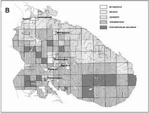
Basing on these theses there has been made zonation of the Kola peninsula according to the complex criteria (fig. 3 a-г).
Modeling of synthetic maps has been made by GIS ArcView. In order to get thematic indices of territorial units there have been developed corresponding thematic maps layers with tables of attributive data on the united geographic basis.
Quantitative indices of complex criteria are calculated on the basis of an algorithm allowing to get synthetic characteristics of territorial units within the united scale and to estimate the contribution of initial (thematic) indices (Tikunov, 1999).
Fig. 3. а - landscape-geochemical potential of geosystems acidification; б - landscape-geochemical potential of geosystems self-purification; в- environmental capacity of landscapes; г - tensity of environmental situation
Thus, the investigation object (a complex ecological-geographical criterion), the investigation itself (quantitative assessment of criterion) and result (a series of electronic thematic and synthetic maps) as a whole represent the system which might be used to obtain new knowledge within the ES. Inclusion of the unit directed toward the creation of GIS assessment ecological maps into the ES structure allows to get the replicable results and control environmental situation by changing impact parameters.
At the given stage of creating regional ES to manage the nature protection in the Murmansk region there have been developed series of thematic layers of electronic maps directed toward the management of environmental situation. For example, series containing data on natural conditions and anthropogenic factors on forming of hydrochemical parameters, critical sulphur loads for terrestrial water and level of their exceeding is directed toward the regulation of brought in acid-forming substances into atmosphere and reservoirs from industrial sources.
Factors of direct environmental impact (anthropogenic) and indirect environmental impact (social-economic) as well as natural ones take part in forming of environmental situation. They form a system where the management connections are directed from the social-economic factors toward anthropogenic and then to the natural ones. Therefore, to determine the measures oriented to the change of environmental situation there are applicable various methods of causal analysis. A significant positive point is the opportunity to apply the causal analysis to stochastic situations. The situation approach gives the opportunity of an adequate description of man s environment and factors determining its state by limited possibilities of formal (quantitative) submission of systems elements and connections.
To change environmental situation means to change factors forming it. In order to make the sound decision directed toward regulation of anthropogenic impact there is necessary to determine the conformity between this impact and state of environment or its component. Environmental situation reflecting the whole preceding history of interaction between society and nature represents a certain process stage of anthropogenic nature change.
For example, if we consider the state of landscape in impact zones of the atmospheric pollution sources, it corresponds to the certain stage of successive change of elements, components and then the structure of natural-territorial complexes (NTC). The singled out industrial stages form a dynamic line and correspond to the standard value of the function of two variables - load for the impact period and its length. The impact index takes on the prognostic contents as well as the pragmatic meaning if it takes account of the load and time factor and is brought into correlation with the initially equal NTC.
The level of impact when there takes place transition of landscape units of the same kind into the next dynamic stage is determined as a critical one. Thus, the critical impact is a variable value interrelated with the concrete timespan, and that is its principled difference from the action levels and similar criteria oriented to the illimited long-term period.
Functional-dynamic approach to the assessment of critical impact on natural-territorial complexes has been realized on the example of the impact zones of mining-metallurgical enterprises of the Murmansk region. At the investigated territory there is represented almost the whole variety of NTC of the Kola landscape region, many geosystems have practically totally exhausted environmental capacity, and the significant area is characterized by high tensity of environmental situation.
Change of landscapes under conditions of aero-industrial pollution is such a phenomenon when regularities being correct for the time series also apply to the spatial series. That allows to describe the process without having available the necessary amount of successively dated data on the basis of static map of geosystems state and the map of loads linked to it. Basing on the mathematical-mapping model realized by GIS ArcView there has been developed a series of electronic maps reflecting the loads by the increasing total from 1973 till 1996 on the uniform system of units of coordinate survey with 400 m spacing.
Critical values and amplitudes of the total sulphur load for each industrial stage have been revealed using the information system model load - NTC state (Makarova, 1999). There has been determined functional dependence between the level and duration of load for separate process stages by transformation of geosystems under conditions of aero-industrial pollution.
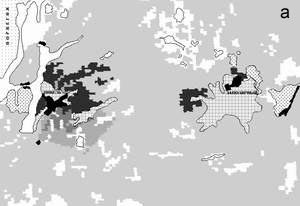
There has been developed a mathematical-mapping model of prognostication and reconstruction of the NTC states (fig. 4 а-б). The modeling results are represented as a kind of animation using multimedia.
Steadiness of NTC toward the sulphur load within the studied territory changes from 0.07 to 0.56 relative units. On the investigation areas there is no question about conservation of mountain NTC of the upper stage, because they have already been damaged. It is more likely to rehabilitate successfully the most ecologically, economically and socially valuable north-taiga complexes. The amount of annual atmospheric depositions when the damage of limiting (north-taiga) NTC will not cause their industrial transformation during 10, 20 and 50 years has been determined taking into consideration production technology as well as its modernization. The obtained estimation values of permissible deposition by conserving the contemporary state of the north-taiga landscapes during the next 50 years are significantly lower than the volumes of action levels calculated according to the health criteria.
Fig. 4. a - state of NTC in 2006 - forecast; б - state of NTC in 197 - reconstruction
Comparison of several prognostic criteria by changing the input data gives the opportunity to chose an optimum managerial decision directed toward environmental conservation.
Regulation of polluting depositions into the atmosphere according to such criteria as action levels and critical loads for separate natural milieus virtually presumes the illimited long-term existence of pollution sources and does not take into consideration the close connection between the pollution response and the real duration of the given anthropogenic factor. Regulations of depositions on the basis of the critical impact (functional-dynamic criteria) proceed from assessment of the real term for using the specific production technology and acceptable changes of environmental parameters.
Thus, creation of intellectual systems of informational support to manage environmental protection in the regions is connected with solution of the problem on scientific-methodical provision of the structural-target basis for such systems. At that GIS are the necessary tools to solve this problem.
References
Ї Makarova T.D., Krasovskaya T.M., Evseyev A.V. Kola Peninsula zonation based on ecological-geographical criteria // Ecological-geographical problems of the Kola North. Apatity, 1999.
Ї Makarova T.D. Landscape-climatic potential of air pollution // Ecological-geographical problems of the Kola North. Apatity, 1999.
Ї Makarova Z.V. Informational analysis of the geosystems change conditions under the impact of deposition load. // Ecological-geographical problems of the Kola North. Apatity, 1999.
Ї Tikunov V.S. Methods of estimating ecological maps production for the Kola Peninsula // Ecological - geographical problems of the Kola North. Apatity, 1999.
Ї Facts, Decisions and Actions - Specifying Geospatial Environmental Information Systems for Management


 Fig. 1. Nature-protective orientation of the Sustainable Development aims
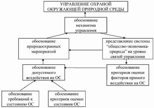 Fig. 2. Structural scheme of scientific basing tasks